

Leuven
In Leuven, rainfall is measured since 2008 with a X-band radar by the water treatment company Aquafin and the Katholieke Universiteit Leuven. In the RainGain project, rainfall data from different sources will be combined and integrated with Numerical Weather Prediction of RMI to obtain for fine-scale rainfall nowcasts. This short-term forecasts can be used to simulate 2D sewer inundations, to support sewer flood forecasting, warning and RTC. Improved fine-scale rainfall estimates also will increase the accuracy of the urban drainage simulation models that are important decision support tools.
Leuven Case Study
Mid of 2007, the Flemish water company Aquafin in cooperation with the University of Leuven (KU Leuven) installed a short range high resolution X-band weather radar in the city centre of Leuven (Belgium) (Figs.1 & 2). The radar observations cover the entire area of the city of Leuven, which is the capital of the Province of Flemish Brabant in Belgium.
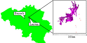
Fig. 1: Location of the city of Leuven, east of Brussels, in Belgium, and the sewer network and rain gauges installed in and around the communities of Winksele, Herent and Wijgmaal, north-western part of the larger Leuven drainage area
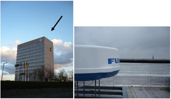
Fig. 2: Location of the Leuven X-band radar of Aquafin, on the roof of the Provinciehuis building.
Water management aspects of the larger Leuven drainage area
The larger Leuven drainage area, as is the case for many cities in NW Europe, suffers from frequent sewer pressurizations and floods. Due to ongoing urbanization trends and climate change it is expected that the frequency of sewer floods will significantly increase in the future. As the sole wastewater utility in Flanders (6,100,000 inhabitants), Aquafin operates about 230 wastewater treatment plants and almost 1,000 pumping stations. In search for an optimum flood management and control strategy, Aquafin prospects several modelling and monitoring possibilities. Tailored action plans are being drawn up, and a cost-benefit analysis of several static and dynamic adaptation and remediation measures is undertaken. This includes the use of Real Time Control (RTC) strategies and the set-up of a nowcasting system, which requires accurate fine-scale rainfall estimates and short-term forecasts using local radar technology. This RAINGAIN project will contribute to this need.
Experimental site
The experimental site that will be considered for the RAINGAIN project is the sewer network of the communities of Winksele, Herent and Wijgmaal, situated in the north-western part of the larger Leuven drainage area (Fig.1). The total catchment area of this network is about 9.13 km2 and counts approximately 16,100 inhabitants. An existing sewer network model has been developed for that region by Aquafin. It contains several combined sewer overflow structures (CSOs) discharging on surface waters, of which four are permanently monitored since 2007. Along with this, flows and water depths are measured in a couple of other points in the sewer system, and rainfall is measured (at 2 mins interval) at four locations. Six more rain gauges (10 mins recording) from the Flemish Environment Agency (VMM) are available in this area, and four more rain gauges will be installed by Aquafin within the scope of the RAINGAIN project.
Leuvenis approximately located at equal distance from the operational C-band radars at Wideumont (Royal Meteorological Institute of Belgium: RMI) and Avesnois (Météo-France). It is worth noting out that the Avesnois radar was installed under an Interreg project (“Radar du Nord”) lead by Météo-France. Other partners were the Walloon region of Belgium, RMI, and different local authorities in the North of France. Moreover, it is very near to the operational C-band radar from Belgocontrol at Zaventem (Brussels Airport). An additional new Dual Polarization radar will be operational from spring 2012 near the Belgian coast at Jabbeke (Fig.3).
In the RAINGAIN project, these different rainfall sources will be combined and integrated with Numerical Weather Prediction of RMI for the purpose of fine-scale rainfall nowcasting. The short-term rainfall forecasts can be used as input in the urban drainage system model of the study case to simulate 2D sewer inundations, in support of sewer flood forecasting, warning and RTC. Improved fine-scale rainfall estimates also will increase the accuracy of the urban drainage simulation models, hence increase the accuracy of these models as decision support tools.
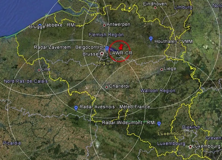
Fig. 3: Location of the SP C-band radars at Wideumont and Zaventem and the DP C-band radar at Jabbeke, versus the location of the X-band Leuven radar
Some technical specifications of the Leuven radar
The Leuven radar is a City Local Area Weather Radar (City-LAWR). It is a radar system based on naval navigation equipment, developed and distributed by DHI Water & Environment (Denmark). The antenna emits electromagnetic waves with a frequency of around 9410 MHz – this corresponds to a wavelength of approximately 3.2 cm – so the radar operates within the X-band. Its peak output power is 4 kW. Despite this low output power, no broadcasting licence would be delivered by the authorities without the guarantee that no waves would be emitted in the direction of Brussels Airport, out of precaution of interference with a ground communication system. After all, Brussels Airport is located only 15 km west of the catchment. The antenna has a width of only 55 cm, protected by a plastic cover (the radome with a diameter of 64 cm) and a weight of 8 kg. This limited size and weight make the system easy to install, and offers more flexibility in selecting a suitable installation site.
The Leuven City-LAWR is capable of delivering data with a spatial resolution of 125 m x 125 m. This high resolution implies less spatial averaging of the errors. On the other hand, the antenna rotates at 24 rounds per minute, taking a full 360-degree scan with each rotation. Each radar image, delivered every minute, is calculated as the average of those 24 scans. The vertical opening angle is 10 degrees up and down when pointing horizontally.
Finding the appropriate location was a critical step in the installation of the system, especially in the urban environment of the region. To find a suitable installation site for the City-LAWR, an empirical approach based on on-site clutter tests was used. In these tests a Micro radar (DHI) was used to carry out test experiments at each site of interest. This was done during dry weather conditions, since during such periods all received echoes can be assumed to originate from ground targets, such as buildings, roads and hill slopes. The resulting images are then used to assess the expected amount of clutter to be expected when the City-LAWR would be installed on the specific site. The procedure is described in detail by Goormans et al. (2008), as well as the results from the candidate sites. From those results, it was decided to install the radar on the rooftop of the “Provinciehuis”-building – the office building of the provincial government of Flemish Brabant –, 48 m above ground level (Fig.2). The system is provided with a broadband connection, which enables remote control and facilitates data retrieval. The system performs various pre-correction steps to the data before storing it locally, such as attenuation correction, volume correction and clutter subtraction.
First calibration of the radar has been done in an ongoing research project of KU Leuven for Aquafin (Goormans, 2008, 2012).
References
- Goormans, T., Willems, P. (2013). ‘Using local weather radar data for sewer system modelling: a case study in Flanders, Belgium’, Journal of Hydrologic Engineering, 18(2), 269-278.
- Shrestha, N.K., Goormans, T., Willems, P. (2013). ‘Evaluating the accuracy of C and X band weather radars and their application for stream flow simulation’, Journal of Hydroinformatics, 15(4), 1121-1136.
- Goormans, T., Willems, P., Nielsen, N.E. (2008). ‘Empirical assessment of possible X-band radar installation sites, based on on-site clutter tests’. 5th Eur. Conf. on Radar in Meteorology and Hydrology (ERAD), Helsinki, Finland, 30 June - 4 July 2008.
- Goormans, T., Willems, P., (2008). ‘Correcting rain gauge measurements for calibration of an X-band weather radar’. 11th International Conference on Urban Drainage, Edinburgh, Scotland, UK, 2008.
- Goudenhoofdt, E., Delobbe, L. (2008). ‘Evaluation of radar-gauge merging methods for quantitative rainfall estimates’. Hydrol. Earth Syst. Sci., 13, 195–203, 2009
- Delobbe, L., Dehem, D., Dierickx, P., Roulin, E., Thunus, M., Tricot, C. (2006). ‘Combined use of radar and gauge observations for hydrological applications in the Walloon Region of Belgium’. In: Proceedings of ERAD 2006, Barcelona, Spain, 18–22 September 2006, ERAD Publication Series, 3, 418–421.