

Paris
The Challenges of the Paris Region
The Paris X-band radar has been installed in the East side of the Paris region, named ”Ile-de-France”. With about 12 millions inhabitants and a huge economical and political weight, this region is one of the major metropolises in the world. Ensuring a sustainable development of this region – i.e. switching from a high vulnerability to resilience – is a shared goal of its inhabitants and its political institutions. With two main drivers – climate change and ongoing urbanisation – stormwater management is a key challenge.
The region is hydrologically complex: two major rivers meet there, their tributaries exhibit highly variable discharge, there is a strong diversity of land-use (see Fig. 1) and there are overlaps between artificial and natural drainage networks. Because of ongoing urbanisation, impervious areas increase (see Fig. 2) and the frequency of pluvial flash floods rises too (see Fig. 3). On the other hand, urbanisation may also reduce the refilling of groundwater. These hydrological features challenge the local ability to manage water as a risk as well as a resource, in terms of quality and quantity. Improved rainfall estimates are needed to limit pluvial flooding and combined sewer overflows in flat areas that today are rapidly being urbanised.
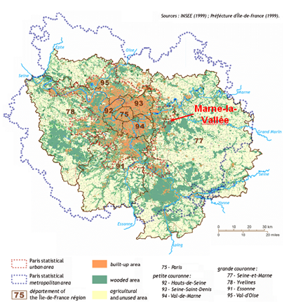
Figure 1: Land use distribution in the Ile-de-France region.
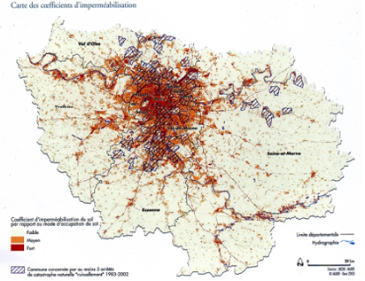
Figure 2: Impervious coefficient distribution in the Ile-de-France region
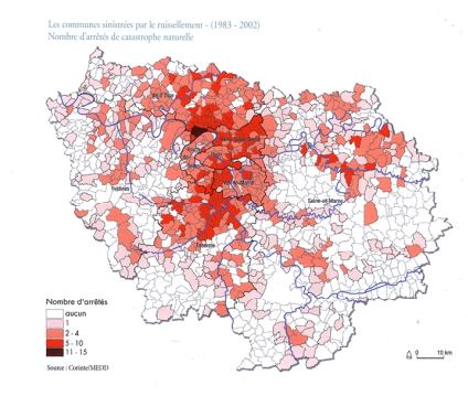
Figure 3: Number of severe pluvial floods suffered by the urban areas in the Ile-de-France region between 1983 and 2002.
Marne-la-Vallée is a strategic location for the improvement of Paris region water management. A X-band radar located in the East of the city will allow the observation of rainfall inputs upstream of Paris rivers and sewer networks. Indeed, although the storms are usually moving Eastward (hence, the weather C-band radar of Méteo-France for the Paris region is located in Trappes, West of Paris), the rivers and sewer networks are flowing Westward.
Besides these hydrological reasons, there is a training need that can be satisfied only in the academic framework of Ecole des Ponts ParisTech where, the theme of water in the city has always been a priority with close collaborations with local water authorities. Furthermore, the chair “Hydrology for resilient cities” has been recently created with the sponsorship of Veolia (also a RainGain partner) that guaranties a long term financial support to this research sector.
Last but not least, Marne-la-Vallée hosts the Paris East cluster: a scientific and technological cluster, sponsored by the Ministry of Ecology and Sustainable Development and the Ministry of Research and Education, that aims to become a worldwide reference in sustainable city construction, maintenance and services, i.e. in shaping our urban future.
Marne-la-Vallée is therefore a great location for the new X-band radar, as well for transnational cooperation. Students of Ecole des Ponts ParisTech will have easy access to the radar and to courses dealing with this innovative tool. Through education, Ecole des Ponts ParisTech will ensure the spreading of the RainGain results in the society. Indeed its students are the future key decision makers who will work in international, national and local water authorities and corporates.
Description of the experimental site
The five French partners will unite their knowledge and expertise – ranging from theoretical analysis of rainfall to daily management of sewer systems – to cope better with intense storms. A special focus will be on management of storage basins and real time control to limit both sewer overflows and pollution.
Location of the new X-Band radar
The new X-band radar is located on the roof of the Bienvenüe building (Fig. 4) in the Paris East campus and right in front of Ecole des Ponts ParisTech. The radar has been installed on a 10 meters mast to avoid masks.
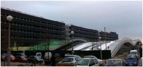
Fig 4: Bienvenüe building, where the new X-band radar will be installed (picture taken on the 25.11.2012)
Available rainfall data in the Ile-de-France
In Ile-de-France, there are several hydrometeorological measurement devices that through RainGain and other related research projects will be reinforced for validation purposes.
Météo-France operates the C-band radar of Trappes (West of Paris) and a rain gauge network. The Val-de-Marne county (Fig. 5) and the Seine-Saint-Denis county(Fig. 6) operate dense rain gauge networks to manage their sewer system. Furthermore, Ecole des Ponts ParisTech will implement a 1D disdrometer network and a 3D video disdrometer to obtain detailed observations of the variability of raindrop size distribution at very small scales.
All these devices will provide rainfall data that can be used to validate the X-band radar estimates at different scale resolutions and improve rainfall estimates and nowcasts.
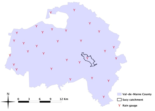
Figure5 : Rain gauge network of the Val-de Marne (CG94) county.
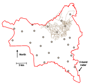
Figure 6: Rain gauge network of the Seine-Saint-Denis (CG93) county.
Hydrological case studies
Several case studies will be dedicated to the basins managed by the RainGain partners Seine Saint-Denis county and Val-de-Marne county. These studies are intended to test how rainfall estimates and nowcasts with a very high level of accuracy can support storm water management improvement.
- Morée-Sausset is a urban area of housing estates, the land is very flat and has no rivers. The case study is carried out by CG 93 and ENPC. Read the Presentation and the Technical sheet.
- Jouy-en-Josas is a partially urbanised and partially covered by a forest, it has a highly sloping land and it is crossed by a river. The case study is carried out by ENPC and SIAVB. Read the Presentation and the Technical sheet.
- Sucy-en-Brie. The case study is carried out by CG94 and ENPC. Read the Presentation and the Technical sheet.